Climbing Mt Tyndall
Last weekend, some friends and I set out to climb Mount Tyndall in the Eastern Sierras.
At 14,018 feet, Tyndall would be the highest I've ever been and I was excited to climb a real Sierran mountain. Tyndall is on the border of Sequoia National park, just north of Whitney, and is one of the 'fourteeners' of California. To even approach it requires a gruelling climb up Shepherd's Pass from the Owens Valley. Once at the pass, Tyndall juts skyward from an immense pile of scree and boulders - John Tyndall, the English glaciologist after whom the mountain is named said: "If nature had intended to secure the summit from all assailants, she could not have planned her defenses better; for the smooth, granite wall which rose above the snow slope continued, apparently quite round the peak and we looked in great anxiety to see if there was not one place where it might be climbed."
There were 4 of us - my girlfriend, her friend Galina, and her boyfriend Eric. The other couple were vastly more experienced than we were - Eric had just finished thru-hiking the PCT and from the sounds of their stories they spent every weekend climbing peaks in the Sierras. This was lucky as, although I have a fair amount of technical experience from climbing in Scotland, and Colette has been hiking in the Sierras her whole life, neither of us had ever done anything on this scale.
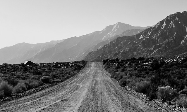
To get to Tyndall, we would drive to Independence, a 7 hour drive from SF - so we left late on Friday and drove into the night. Around midnight, and just north of Bishop, we turned off the freeway and found a patch of scrubland to camp on.
There's a certain romance to sleeping outside on a piece of old tarpaulin under the stars; in the middle of nowhere, and only the lights of the distant freeway and the powerlines to keep you company. The moon was bright enough to see the scrubby bushes and spiky thorns, and the only noise was the occasional wind of a passing big-rig.
We woke at the desert sunrise and headed into Bishop to pick up our permits and some last minute supplies. We also ate a big breakfast at a diner there, filling up with fuel for the long ascent ahead.
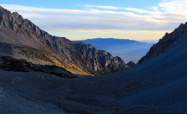
The trailhead is at the end of a bumpy dirt road from Independence - the desert rises up dramatically into the mountains, and the parking lot is at the foot of a steep walled gorge at around 6,000 feet. Shepherds Creek is too steep for a trail, so the start of the ascent is in the Symmes Creek drainage. After a couple of river crossings to avoid the steep canyon walls, the trail switchbacks up to a saddle just over 9000 feet. In this time, the plantlife changes from the typical desert scrub, including prickly pear cactus, to upper montane forest, with aspen and pine clinging to the steep rocky slopes.
We stopped for lunch at the top of the saddle - we'd been climbing for 2 hours and the view of Mount Williamson was our reward as we took a break before heading into the Shepherds Creek valley. From the saddle, the trail descends quite steeply across scree slopes, and on these we saw the trails of Bighorn sheep. Having lost around 1000 feet, the trail climbs around a bluff to Mahogany Flats - a beautiful grove of trees on the river. As we were climbing late in the season, the Aspens were a beautiful yellow against the dark evergreen of the pines and the dirty gray of the steep valley walls.
Mahogany Flats was where I first started to feel the altitude. I've been altitude sick a couple of times before - once on the other side of Sequoia NP and once while climbing Cloud's Rest in Yosemite. It's a weird feeling - you take a couple of steps and all of a sudden your heart is pounding as if you just sprinted a quarter mile; you rest for a second and it's normal again. Not wanting to be hit by it again, I'd been taking Diamox for a few days - it's a drug that raises your blood acidity increasing your breathing. When I asked my doctor about it he told me 'the most important side affect is that it makes beer tastes weird'. Despite this, I had decided to give it a go. Unfortunately, it seemed like it hadn't worked.
Altitude sickness is a weird condition - it affects people seemingly at random and isn't correlated to physical fitness or age. Even stranger, it can affect people who have never had it before, or disappear and not return. The best way to avoid altitude sickness is to spend time acclimatizing - typically a day for every thousand feet of ascent. It's also better to climb high and sleep low, as the body recovers better at lower elevations. Because of our tight schedule, and the large amount of elevation we were gaining, this wasn't entirely practical, so I told the others to head on while I sucked it up and kept moving.
Because of this, I was around 10 minutes behind the others at our next stop a couple of thousand feet higher at Anvil Camp. We weren't that worried about the separation - I had a compass and a map and the trail was fairly straightforward - we made plns to camp just over the col beside a lake just below Tyndall.
From Anvil Camp, the trail meanders through a boulder field, before gaining 2000 feet in a set of harrowing switchbacks up the back of the couloir. I was lagging a long way behind at this point - the altitude was really hitting me hard. For every step forward my heart beat three times, and my chest was burning with the huge breaths I was taking. It was late in the day, and I was just entering the couloir as the sun set. In the dying light I could see a tiny figure on the top of the col, so I flashed my torch at them to signal that I was alright.
The light faded fast, and soon I was relying on the tiny spot of light that my torch flung feebly onto the rocks. I felt a little drunk - another symptom of the altitude - and in dark emptyness between the cold stone walls of the couloir it was quite lonely. I knew I had to keep moving - I didn't have the tent and I would barely have survived the freezing night if I'd bivouaced. But every step was pain, and I was exhausted.
I kept on going, step after step, and after an hour or so of climbing I saw a light descending - Eric had come down to check I was alright. They'd been watching my flashlight wind it's way tortuously around the switchbacks, but I'd gone behind a rock, and they were worried that I'd stopped. He had a thermos full of hot tea, which tasted just about the best thing in the world. I was actually only a couple of switchbacks below the pass, but the trail got worse, and I was thankful for the brightness of Eric's headlamp.
Together we reached the top of the pass and found camp all set up next to a lake that was all but invisible in the dark. I was too exhausted to eat, so they helped me into my sleeping back and I passed out. Around 30 minutes later I woke up and vomited my stomach up outside the tent. I was pretty messed up.
Camping at altitude in the cold is not pleasant, and due to my own stupidity, I'd brought a lighter sleeping bag, so it was a shivering, cramp filled night. I awoke the next day feeling a lot better however. Embarrased at how weak I had been the night before, I was keen to tackle the summit.
We took the Northwest Ridge - the least steep of the ribs that ascend from the boulder field towards Tyndall's jagged summit. It was a fairly arduous ascent - essentially 2000 feet of boulder hopping, with very few larger slabs or easier climbing. I found that if I took it slow enough, and took pauses between bigger moves, I could keep my breathing under control. Despite the fact that I still felt sick and hadn't eaten anything, I seemed to have a lot of energy too.
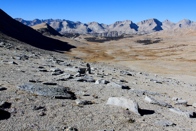
The views were amazing, and as we ascended, they got better. The high alpine landscape is incredibly barren, but a river flowed fractally down the wide glacial valley from the pass. I could see our camp next to the lake that, although only 100 feet from the col, outlet to the other side, and thus flows west.
It's interesting to think about the water - virtually all of the rain that falls on the Sierras is diverted before it reaches the sea - if a raindrop were to fall on the east side of the col, it would flow down Shepherds Creek and into Owens valley, where it would be piped off to the thirsty maw of LA. If it fell a few feet to the west, however, it would make it's way south into the Kern river, and eventually ending up in irrigation in the Central Valley.
Above the valley rose rocky peaks in every direction. Fingers of rock jutted defiantly into the sky, and jagged crests tumbled onto rocky plateaus. Eric and Galina talked about each peak like they were old friends, and I guess in a way, when you fight your way up a mountain you do begin to know it intimately.
By the time we reached the ridge the sun was high, and the moon was setting behind a distant mountain. A large notch separated us from the ragged ridge, so we had to climb around a large rock. Looking down would have been a big mistake, as we were perched on a steep granite slap above a 1000 foot cliff.
Some more exposed scrambling, and Colette decided wisely that she was going to sit and enjoy the view, while we more foolhardy adventurers would bag the summit. This we did with some more clambering, reaching the overhanging rock at the peak. We signed a register in a metal tin, and took some celabratory pictures, but the wind was howling, and this was no place to linger. I was at the highest point I've ever been at.
The others raced back to check on Colette, and I returned as fast as my straining lungs could manage. I caught a glimpse of them behind a rock, before my foot slipped and I was falling upside down towards the rocks. Somehow I managed to hook my leg around the rock and one of my flailing hands found purchase, and I was hanging inverted above a rock off which my head would have bounced into oblivion. Heart racing, I recovered myself and joined the others. Besides a blooming raspberry on my thigh, the only other casualty of the fall was the edge of my brand new iPhone, which got all scratched. Well, if you're gonna scratch it, you may as well have a sweet story.
I don't have much to say about the descent other than climbing down boulders gets old really quickly - it's not easy on the knees. By this time I was feeling woozy from the altitude again and my dry cough signalled that I was pushing it too hard.
We decided to stay at our camp by the lake instead of descending as we got back quite late in the day, and we wanted to make dinner before dark. I managed to get a couple of spoonfuls of quinoa down, but the nausea was back. That night was very unpleasant. I was shaking - a mixture of cold and exhaustion - and I couldn't sleep. I imagined that it was pouring with rain outside, even though it was a dry night. The only real cure for altitude sickness is to descend, so the next morning I was glad to get an early start. We were moving by 6:30, and were at Anvil Camp by 7:30. As the sun warmed the valley, I felt a lot better. Descending is a lot easier than ascending, and we were at the car by around 1. I'd been fantasizing about hot-springs the since the beginning of the trip, and on the way back we stopped at one just south of Mammoth Airport.
It was great - a concrete and stone tub in the middle of nowhere, accessed by a wooden boardwalk over alkaline mud. The water felt great on our aching legs. Apparently there's loads of these hot springs across the Owens Valley.
And then the long drive home. It was a great trip. We talked about how there are various types of fun. Type 1 fun is fun when you do it, and fun looking back. Type 2 fun is painful when you do it, but you look back on it fondly. This was definitely a type 2 fun weekend - there was a lot of pain, but the high points were amazing. The Sierras are beautiful, and it was incredible to see some of the more inaccessible parts.
I definitely learned some lessons the hard way - I'll never take the wrong sleeping bag on a trip again - and there are definitely things I want to improve. The altitude sickness was such a downer, I'm definitely going to have to work out a way to acclimatize for future trips. Perhaps an extended period at altitude may help as well.
I'd like to thank Eric and Galina for taking such amazing care of us as well. I was a feeble wreck most of the time, and they did a great job of looking after us and having hot tea at the right points. You guys rock.